 |
| Entry to Skagway |
I was up at 6 for breakfast and to get a reservation at 7 for the
train to White Pass on the Yukon RR Route. I joined Marsha and Marty on the tour.
This was one tour that was only about $5 less to purchase it off ship, so I bought it on ship that a.m. to be sure to get a ticket. It was fascinating to go along the route that the miners used.Howard didn't go but waved to us as we left.
 |
| Marty & Marsha getting on train |
This was one tour that was only about $5 less to purchase it off ship, so I bought it on ship that a.m. to be sure to get a ticket. It was fascinating to go along the route that the miners used.Howard didn't go but waved to us as we left.
 |
| Guide on train and back of heads of M & M |
 |
| Dandelions |
Along the way, we saw tons of dandelions. We saw them throughout Alaska. I was told that the yellow flowers are the first signs of color in late spring, so natives enjoy them.
 |
| Engine that Could not |
We also passed the cemetery about 2 miles out of town. Marsha and Marty went there later in the afternoon and also walked to a waterfall a bit behind the cemetery.
As we passed the train area, I saw a big house on the hill...a common scene in other towns we were in too.
The brochure they gave us had the map of the route. The RR path was very very difficult to construct. It went from sea level at Skagway to White Pass at 2865 feet. The path sometimes was very narry and very close to the river. Old RR cars were often dumped at the side of the road and covered over to keep the RR track road from crumbling into the river. One was uncovered for us to see.
As you can see from the map, we followed the Skagway River.
The folder with the map also had great photos of the flora in the area along side the train:
We saw a lot of the Western Columbine, tones of Cottonwood along side the river, lots of Sitka Spruce,
Hemlock, fireweed, Alpine Arnica, Shrubby Cinquefoil, Monkshood, Cotton Grass, Lupine (much smaller than ours, etc.
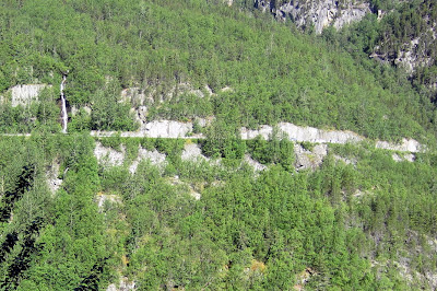
The main highway was on the other side of the gorge. You can see it here, with a waterfall on the left.
I think that Fred and Ruthy took the bus to the pass so they traveled on this road. Along the way just below that road, we saw the trash facility for Skagway.
I was surprised at how far out of town it was.
The road was extremely difficult to build and was mostly built by men who wanted to go after the gold but needed to get through the pass so worked on the rails.
You can see how much they had to blast. Below is an example of a narrow passage.
Here is a photo of the train going over a high wooden tressle bridge:
It must have been quite a feat to build the bridge. He is a better photo of it.
And here is a photo of one no longer in use.
There were stunning views along the way including the following ones:
Above is the waterfall near the road. I took it from outside the train car.
As we got closer to the summit, we could see the trail that the men walked, often with donkeys carrying supplies.
At different times we turned the bend and could see Skagway in the distance, with the mountains in the background. If you look carefully, you can see ships in port.
Above is a close-up photo of more mountains.
As we got closer to the pass, there was snow along the side of the train. As little as two months ago, the snow was 4 to 6 feet deep along side the tracks.
Lake near pass...two weeks ago it was frozen over. Since the pass is at 2865', the weather definitely changes as we climbed. This tourist train tour only goes through mid-September, but they work to keep the tracks clear during the winter for other reasons. The snow banks (from keeping the tracks clean) are often higher than the train. The snow remover below was on the front of trains to keep the tracks clean.
 |
| Five flags at summit |
this is an old ranger cabin at the summit, no longer in use. And the police are no longer called NW Mounted Police.
We saw a number of animals along the way. Unfortunately I didn't succeed in getting photos of them. They included 2 brown bears and some mountain goats. The scenery was great and we learned a lot about the miners who built the road and the elusive gold they were chasing.
We walked a short distance back to the ship for a yummy buffet lunch including mushroom and goat cheese strudel. Sometimes the vegetarian food was "hidden" so it helped to look at the posted menu. I had the mushroom and goat cheese strudel among other things! Yum! I think that was the day we also had a quinoa with cranberry dish. Double yum.


No comments:
Post a Comment