(Some of the names of places below are underlined and written in blue. If you click on them, a new window will pop up with more about the specific places.)

Along the way on highway 12, we passed Oso and four miles east we saw where the major landslide occurred in March 2014 and killed over 40 residents.
 |
| Picture from the internet |
 |
| Picture take through the window of the van |


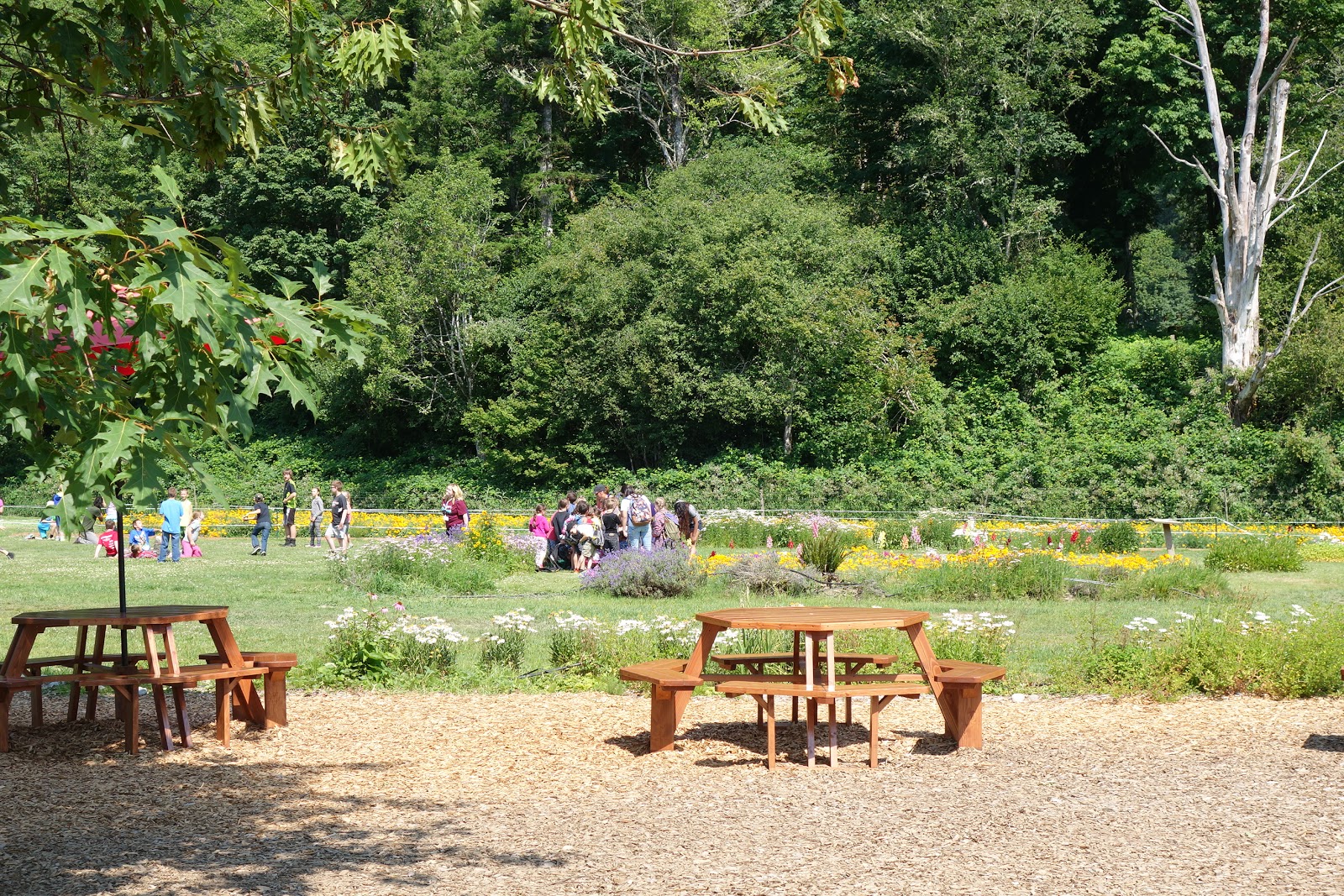
Our first stop (not counting the rest stop), was at the Cascadian Farm to stretch our legs, use the bathrooms, and buy some ice cream or Cascadian products.


 |
| lavender |
 |
| Poppy polinator field |
Before we entered the center, a volunteer was talking about the black and grizzly bears in the area and had models of both as well as their claws.

There are still 400-500 black bears in the park but only 2-4 grizzlies as most had been killed by hunters. However up to 6 more have been sighted near the Canadian border. The grizzly also has a concave facial profile, smaller ears, and much larger claws than the black bear. The latter has unusual claws with underparts carved out to make it easier for them to dig for insects in the soil.


Both animals can be various shades of brown or black, but the grizzly has a hump between its shoulders,
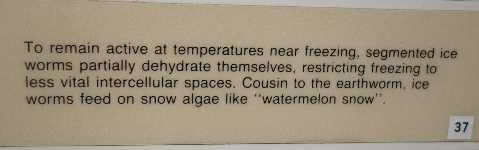
There was a lot of good information inside the information center.


On the back patio we ate our sack lunches,

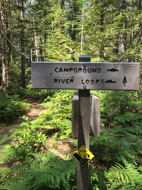
Afterwards, most of us went for a short hike out to the Skagit River to stretch our legs and see the pretty scenery,


 |
| Lots of sword ferns along the path--very quiet with few others on the path |
 |
| Lots of these purple flowers by the river--were they fireweed? |

The painting on the rock below was inside the entrance to the visitor center. There were some real petroglyphs along a boardwalk path exiting to the left outside the back of the center which some of our group saw.
 |
Then some of us watched an 8-minute movie on bears in the park.


We drove on to the Colonial Creek campground, 24 miles east of Marblemount and 63 miles west of Winthrop, to walk on the Thunder Knob Trail.


The path was a bit rocky at first as we walked through a dry stream bed.


While the information online said that the incline was a gentle 425 feet, signs at the site said that it was 625 feet, which was much more believable. On the hike we saw the surrounding peaks

and views of Lake Diablo.

as we sat and marveled in the view.


 |
| Dina and Hadiyah |


Jill brought an amazing array of food, much from Costco. We all participated in preparing the meal and cleaning up. Green and fruit salads were made. Onions and tomatoes sliced. And Jill cooked beef burgers and veggie bean burgers for dinner.


 |
The area where we ate dinner. is above Chickens were fed scraps to the left.  |


Some views down the road from the farm:


Lots of pine trees on the east side of the mountains!

The next morning after a wonderful breakfast of yogurt, oatmeal, eggs, fruit, etc. we also made sack lunches and left for our alternative tothe Patterson Mountain hike as it was 4 miles RT with a 1070' elevation and we wanted something that would work for all of us. So we went on part of the Patterson Lake Trail.. We headed out by 9ish. We drove through the town of Winthrop on the way and passed by a rather famous foot bridge.

We stopped at Sun Mountain Lodge first, near the trail head to verify where we should start our walk.
Several people walked through the gift shop and enjoyed the view from the patio.


Several people walked through the gift shop and enjoyed the view from the patio.

The travel expert at the lodge marked the path for Jill for us to follow.
 And we all headed out in the heat of the day for our 4.5 mile walk! We saw a Henna's Chick flower, poking up from a ground cover.

We went down the Chickadee path. The paths were marked in some places for walkers, bikers, and those on horseback.
 Another pretty flower along the way.


 And Jill captured a great pictures of this bunny crossing our path!


Patterson Lake through a view of wild wax currant berries! Lovely photo, Jill!


And to whom did the foot prints below belong?


Lunchtime below--probably where I (Dina) lost my camera. :( But it was found about a week later and I eventually got a call from Sun Mountain Lodge that it was brought to them. I gladly paid for postage for it to be sent to me and some of the photos from this section and before are from my camera. YAY!!!


Some of us went to a pizza place for dinner. Others headed to a Mexican restaurant. By 7:30 we headed back to Brown's Farm for an early night.
After another good breakfast making our sack lunches, and taking group pictures,

we packed up, loaded the van, and headed to the Mazama Store on the way out of town. It is open every day from 7 a.m. to 6 p.m.


Many of the vendors of products are local.
 I loved the rocking horse below.

Everything in the kitchen is handmade. Jill and Mark told us how delicious the baguettes were.

While waiting for others, I walked down the road to take a picture of a sign we saw as we approached the store. It made me smile.
 We then headed back on the North Cascades highway (SR 20). Click on the link to the left to read the history of the highway. The final part of that road to connect Western and Eastern Washington was finished in Sept. 1972.
Our First stop was at Washington Pass ( 5477 ft). The first picture was taken from the van as we drove toward the Pass.

The Washington Pass Overlook Trail was designated a National Recreation Trail in 1978. The path is short--about a half mile loop, but the views of Liberty Bell Mountain and the surrounding mountains are stunning!


 Several poems were displayed to help viewers enjoy the scenery: Here is one:


The middle of the loop was a bit tricky to climb and not all went to the top.


Our next stop was a magnificent overlook of Diablo Lake.
 with lots of signs explaining the geological details of the area
 and a great explanation of why the lake is the color it is,


We had fantastic weather including a cooling breeze. The views from these sights were spectacular....one of the highlights of the trip!
Our final "big" stop was at the Environmental Center at the North Cascades Institute. To get there, Jill had to drive over the top of the Diablo Dam, a first for her. (I actually took these photos as we were leaving.)


 We learned from either Mark or Bert that a man is traveling to as many of the US National Parks that he can in memory of his dad, and we saw that man's van parked near our van!!

 A great T-shirt at the gift shop.


 Here are examples of the bear-proof trash cans we saw in many places:


A huge fungus growing on a tree.


 A lean-to built in days gone by


Many thanks for Jill for arranging this very special trip! And thanks too to the great fellow travelers who make the trip as wonderful as it was.


Patterson Lake through a view of wild wax currant berries! Lovely photo, Jill!

Trail alongside the lake


We wondered what the structure below was....a temporary shelter when the river was a bit lower perhaps?


 |
| A view near the bottom of the lake |
 |
| A field past the lake |

Lunchtime below--probably where I (Dina) lost my camera. :( But it was found about a week later and I eventually got a call from Sun Mountain Lodge that it was brought to them. I gladly paid for postage for it to be sent to me and some of the photos from this section and before are from my camera. YAY!!!

After the long hike in warm weather, we headed back to the cabins to clean up before heading to the town of Winthrop to wander around and have dinner. Mark especially wanted to get to the MethowConservancy office (someone please clarify) before it closed at 5 as he was a member.
The center of the town of Winthrop is very cute with lots of attractive stores and a good ice cream and chocolate shop too. Winthrop is home to the nation's largest cross country ski area with many other winter sports available. And in spring and summer, it is great for hiking, biking, birding, horseback riding, and many many other things.
Some of us went to a pizza place for dinner. Others headed to a Mexican restaurant. By 7:30 we headed back to Brown's Farm for an early night.
After another good breakfast making our sack lunches, and taking group pictures,

we packed up, loaded the van, and headed to the Mazama Store on the way out of town. It is open every day from 7 a.m. to 6 p.m.


Many of the vendors of products are local.


Our First stop was at Washington Pass ( 5477 ft). The first picture was taken from the van as we drove toward the Pass.

The Washington Pass Overlook Trail was designated a National Recreation Trail in 1978. The path is short--about a half mile loop, but the views of Liberty Bell Mountain and the surrounding mountains are stunning!


Our next stop was a magnificent overlook of Diablo Lake.


We had fantastic weather including a cooling breeze. The views from these sights were spectacular....one of the highlights of the trip!
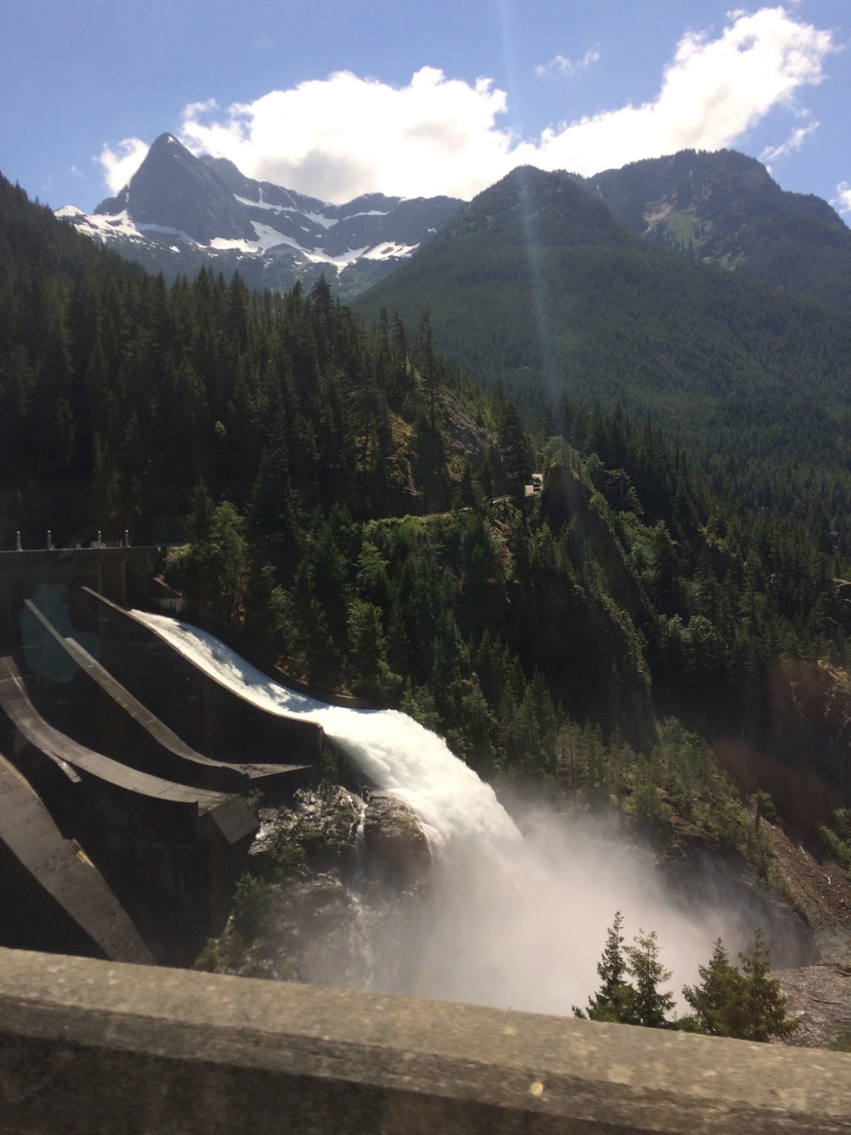
Our final "big" stop was at the Environmental Center at the North Cascades Institute. To get there, Jill had to drive over the top of the Diablo Dam, a first for her. (I actually took these photos as we were leaving.)


The Environmental Learning Center was extremely impressive, with educational programs for schools, families, college students and those studying for a special M. A., etc. 2,500 fifth graders from Bellingham and nearby areas attend a special school program here annually. For some of the programs such as the mountain school, meals are vegetarian as part of the understanding of the impact of raising and eating meat.
We ate our lunches and then listened to a very informative talk by Calvin Laatsch on the partnership with Seattle City Light, the local environment, and programs at the center. He also told us about the creation of the three dams, Diablo, Ross, and Gorge, along the steep gorge, starting in 1928. The Ross dam walls were supposed to have been 60' higher but that would have caused Ross Lake to go into Canada, and the people there did not want to mess with the natural formations. It is the 4th largest watershed in the U.S. The walls were 380 feet deep and no salmon came up this way. It was interesting to find out that the dams did not have as much impact on native life as those on the Columbia River and elsewhere did because the Gorge was so steep that it was not used as much by the Indians. They have a massive compost project and it all goes back to local farms. When students visit, they see it in action. 70% of the food in the dining halls is from 150 miles or is organic or both. There are 23 rooms with 90+ beds in the lodges for all the programs that they host. They do wilderness environment management combined with the human impact on the area. There are some weekends when they host volunteers who help with projects in the area.

And while we were listening to the lecture, we were distracted by a beautiful off-white deer crossing a path near the center and then resting in the grass.


Some of us had coffee in the environmental center dining room.
Then we headed down toward the river for one last walk.


A huge fungus growing on a tree.


And one last picture--not sure whee it was taken--maybe Winthrop as Charla is wearing a dress...but very cute!

