
We traveled down to Yakima, over a large bridge, and


 |
| Mt. Adams |
 |
| Mt. Rainier |
In Yakima we got great advice at the information center and then headed to Sarg Hubbard Park where we walked along the Yakima River on the paved Yakima Greenway Trail for about an hour.


We saw a beautiful black bird w orange markings on the upper part of its wing, and then we meandered into the arboretum and passed it into a beautiful park


On a private lake owned by the cement company on the right of the trail we saw a family of waterfowl.

On the way back to our car, a wonderful volunteer stopped to refill out water bottles. It was sunny in the high seventies, about 23 C. The next two days will be hotter, with temperatures closer to 90.
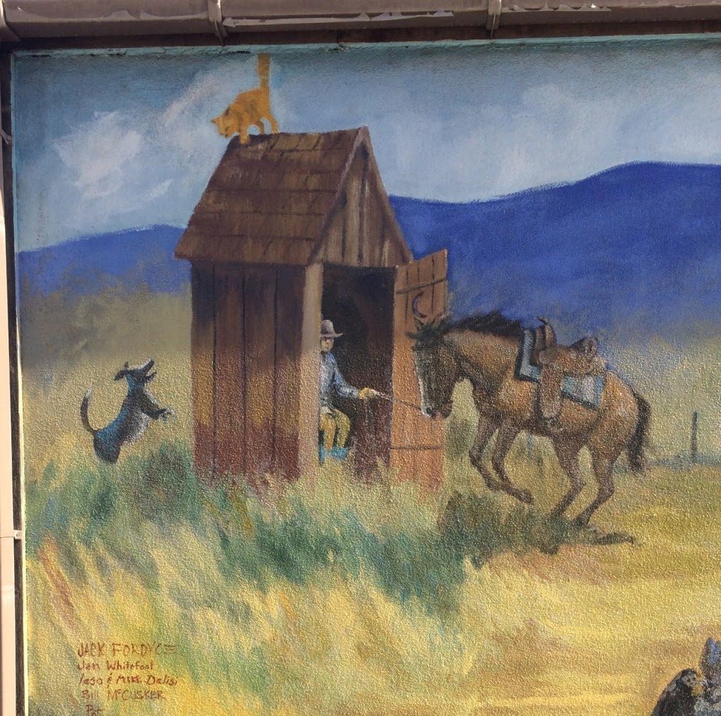
After that we headed down to Toppenish, famous for its 76 outdoor murals. We had a delightful time walking and discovering over 30 of them!
I was in Toppenish with Howard about ten years ago, a town of about 10,000 people about a half hour south-ish of Yakima. Our two focuses on this trip were to see the Yakama Nation Cultural Center and as many of the 76 large murals as possible.
The museum is wonderful, filled with dioramas, history, artifacts, and stories of the Yakama nation. It opened in 1980, and is one of the oldest Indian museums in the US.
 |
| Petroglyphs |


Nava Gazitt and I were very impressed by the values presented.
There was also a nice display of a sweat lodge. I had not realized that the people used it daily, for spiritual and physical health.

We were saddened to read about how Chehilo Falls, an important social and economic center for the Yakama, was destroyed when a dam was built on the Columbia River. You can read about it in the picture below.

The disruption of family life by missionaries and other whites in told poignantly below.

We drove to near the center of Toppenish, parked in the Dairy Queen parking lot, and then began our search for murals. One of the early ones that we saw was called House Calls. As you can see, they are prominently displayed on streets.


The Old Saturday Market
People came from miles around to buy and trade livestock, produce and many other items at the market in the mural below by Idaho muralist Robert Thomas. The wall was built by a local bank specifically for this mural.


Below: Braceros (Mexican laborers) in the Yakima Valley


And one of our favorites:


We headed back to the car, stopping at Dairy Queen for ice cream and thus feeling a bit less guilty for parking in its parking lot. Toppinish was a very cute town. There were many simple houses, but the yards were well cared for.
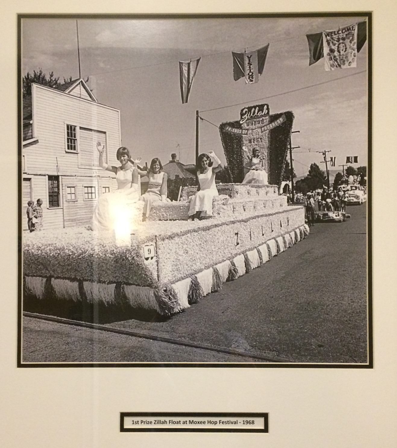
Then we drove on to Zillah and the Vintage Best Western Plus hotel.
Then we drove on to Zillah and the Vintage Best Western Plus hotel.
We had planned to try the Mexican restaurant next door, but Peggy, the very helpful assistant manager, told us that the hotel served chili in the early evening. We were both tired from the day, so we used leftover veggies, etc from our packed lunch to supplement the chili, after we had soaked in the hot tub by the pool. Peggy put us in the newer (2-year-old) wing of the hotel, and it was lovely. We also enjoyed the vintage photos of the region on the hall walls as well as classic older books in the lobby.
 | ||
|

 |
| Zillah 4-H group, 1947 |
 |
| Toppenish Hospital, 1910 |
.The next morning we stopped at the landmark Tea Pot Gas Station, named for the Tea Pot Dome Scandal in 1921-22.

It was next to a tiny park memorial to fallen firefighters. And nearby will be a memorial park for local use.
We then drove through Yakima Wine country, off of the main road, and enjoyed seeing the countryside.
Nava especially enjoyed the scenery, mild rolling rocky hills that still had a touch of green from the heavy spring rains but that would soon be totally brown and desert-like.
Since we were in wine country, we decided to stop at a winery or two. Since we had tried 14 Hands wine before, that was our first stop.

A "hand" measurement is the height of a horse, holding the hand horizontally.
 |
| A mural outside the winery |

The place was stunning --elegant--and built about two years ago.
Nava and I shared a tasting of seven different kinds of reserve wines which are only sold here and not in stores.

We usually prefer red wines but really enjoyed the white ones we tried too. The seven sips that I had, even after a big breakfast, were definitely enough for me!!

I've been to tastings three times before, in a similar area in the Yakima Valley, on the Golan Heights in Israel, and near Lake Chelan, but these wines were much smoother. And in the end I ordered a short gift subscription for my daughter and son-in-law on their upcoming first anniversary and for moving into a new home.
We then headed to the nearby Walter Claire Wine and Culinary Center, a non-profit which just opened a few months ago.

It is not a winery but does sell wines and highlights a different state winery, one of the 900, each month. Its main purpose is educational and it also hosts conferences.
Another delightful woman worked there and explained the center to us. A number of displays, some interactive, filled a large room, telling us the story of modern grape growing and wind making in the area
Walter Clore worked at WSU from 1937 and was known as the father of Washington wines, although he was not a drinker.

Wine making in Washington can be traced back to a Hudson's Bay Company outpost in 1825,but it wasn't until Walter (a man who loved playing in dirt!) started researching and developing the soil, climate and other conditions, did wine making really take off in the area. He discovered which European grapes worked best in the climate in Eastern Washington. Now Washington produces some of the best Cabernet, Chardonnay and Merlot grapes!
Some of Clore's slides were enlarged and on display in the exhibit.

Even during prohibition, wines continued to be produced as only the commercial selling of wines was prohibited, not the producing.


There were great educational displays in a lovely open room, a very helpful staff person , and a lovely view of surrounded irrigated areas.


We saw pictures of the grapes and leaves of the main wines produced here too


Also 70% of the hops used in the US is grown in this area.
We saw several jars near the tasting area and found out that when wines have a certain taste, it sometimes helps to smell the fruit or other item first which awakes the taste buds so that one can better taste that item in the wine. Wow!!


Out the back there was a great view of the surrounding irrigated land and land near the river.


We Then stopped down the road at the home of Chukar Cherries and had some greats snacking that satisfied our sweet tooth/teeth. Yum!

Our next stop on this very hot day was the Tri-cities, Richland (population about 50,000), Kennewick (75,000) and Pasco (70,000), near the Hanford site.
We were very impressed with how nice a city Richland was.


We Then stopped down the road at the home of Chukar Cherries and had some greats snacking that satisfied our sweet tooth/teeth. Yum!

We were very impressed with how nice a city Richland was.
First we picnicked on part of the 12-mile Sacajawea trail along the Columbia River.

 We then walked a bit under two miles, starting at the Columbia Point Marina Park and walking past some lovely riverfront condos.

Other walkers told us there were many such lovely paths throughout the area--a delight for bikers, walkers and joggers.


Other walkers told us there were many such lovely paths throughout the area--a delight for bikers, walkers and joggers.

We noticed trees like the ones below used along the river in many places, acting as a wind break.

There were different educational markers along the path with information of area birds, including water fowl.


Even though we carried water and wore hats, the 90 degree heat really exhausted us! We didn't notice at first because of the breeze.
Our next stop was the REACH museum just outside of Richland in Kennewick. It opened in 2014 to tell the story of the region, especially what happened at Hanford and the Hanford Reach National monument.
As early as 10,000 years ago, ancestors of many of today's Indians including the Yakama and Nez Pierce, hunted, fished, and gathered plants along the "reach" of the Columbia River.


It then goes on to tell of their animals on the ground, birds, fish, and native people who lived there and how they worked in harmony with the land and animals.


The creation of hydroelectric dams, in part built by WPA funds, significantly changed the way of life of some of the native peoples.
The first big changes came to the land when more white settlers came:
There were few non-Indian settlements in the area of the Hanford reach until the 1870s when the small farming towns of Hanford and white bluffs established but many homesteads were abandoned because of the lack of irrigation. By December 1942, only about 1500 such families were living in the area.And then war...

In December, 1942, the military planners of the Manhattan project, the top-secret U.S. effort to build an atomic bomb during World War II, recommended Hanford as a site for the world's first large-scale nuclear reactor. It was a relatively unpopulated area, with a good water power source, geologically stable and easily defensible. I had always associated Los Alamos with the Manhattan project and not Hanford, other places in the US and even in Canada and maybe England.

The next month, the US Army Corps of Engineers bought more than 400,000 acres of land in the basement basin, including farms, the towns of Hanford and White Bluffs, and several Indian villages. All the residents were ordered to leave in less than 30 days. The original HanFord site was more than half the size of Rhode Island.
Buildings were hastily constructed for work and people to live, and with in a month or two, tens of thousands of workers, many with families, were brought in. At its peak I think they were 100,000 people, but definitely more than 50 or 60,000.


Here are some interesting facts about the Hanford camp:
There were eight mess halls that could accommodate 2,700 workers each at a time.
10,000 newspapers were sold each day.
Hanford had the largest general delivery post office in the world.
40,000 employees were housed in barracks.
At one time, Hanford was the largest voting precinct int he U.S.
Nine reactors were built and operated on this site.
262,000 people were interviewed and 94,307 were hired.
250 cows were needed to supply the milk for one breakfast.
30,000 donuts were eaten every day during Hanford's construction.
16,000 packages of cigarettes were sold each day.
250,000 pounds of meat were used for all mess halls in a week.
12,000 turkeys were used for Thanksgiving.
Workers of color were segregated from white workers, and at times they were separate men's and women's barracks.

People were discouraged from leaving, so many more practical places were built such as grocery stores, a small movie theater, medical clinic etc.
 And, of course, this was highly secretive, so people could not talk about it, and most didn't even know what they were working on. Less than one percent of the Hanford workers knew the true nature of the site's mission. Some may have guessed, but others only found out when the newspaper printed that one of the bombs dropped on Japan was from Hanford.

After watching an excellent movie and regained some energy, we walked through the rest of the museum and saw pictures of housing and different places where people lived at the Hanford site. There are also interviews with people who were children at Hanford and what their lives had been like. It was highly educational and shocking.


While many workers left after the war, the start of the Cold War was a reason to continue work at this site, and for the US to build a stockpile of nuclear weapons. Until the late 80s every 10 years there were cyclical ups and downs so the work continued at Hanford. Below is a list of "proxy" wars that "concerned" the US in varying degrees..


Environmental concerns at Hanford were put aside because of the immediate needs of the country, especially during World War II, and today this place is the most polluted such site in the country, Many scientists say that it will never be totally cleaned up.
Senator Patty Murray introduced legislation in 1995 and 1997 to seek Wild and Scenic River status for the Hanford Reach but Senator Gordon was against it. They then turned to President Clinton, and in 2000, he designated the area as a national monument under the 1906 Antiquities Act which allows presidents to act without congressional approval to safeguard areas of national historic and scientific interest.
Unfortunately, this is one of the national monuments that President Trump wants to take off the list of monuments,
Since much of the area is still severely contaminated, it would be horrific to open it to development. When I lived in Spokane, I knew a woman who had grown up near Hanford in the Tri-Cities, where people were called "downwinders." She later developed a fatal type of cancer that was commonly known to be caused by the pollution in the air from the contaminants at Hanford. There have been many others like her.
The receptionist at the REACH museum was very helpful, I was shocked to learn from her that until this museum opened about three years ago, there was no other museum in the area that dealt in depth with all that has happened in the Hanford area. There was a smaller center that talked about a bit that had happened in the Hanford but this center was very much needed.
It's definitely worth a visit!
Tuesday afternoon we left Richland and headed toward Walla Walla in the southeast corner of Washington state. We were surprised and amazed by the huge number of wind turbines along the way.

Walla Walla is the home of Whitman College, a very good liberal arts college, and also famous for Dr Marcus Whitman and his wife, who were medical missionaries in the region in the 1800s.
Nava had found a map online of a tour of historic downtown Walla Walla, and the receptionist at the Reach museum in Richland kindly printed it out for us.
After checking into our Comfort Inn hotel, we headed to downtown Walla Walla, and parked next to the first stop, the historic Marcus Whitman Hotel, which was started in 1927. It is now the fanciest hotel in town, and has beautiful furniture, an old telephone that functions and lots of lovely antiques.


It also had a nice mural in the new entrance:

Across the street from the hotel was a statue of PeoPeoMoxMox, the chief of the Walla Walla tribe who helped write a treaty of 1855.


 |
| Yellowbird Returns, by Walla Walla artist Roger McGee |
The historic part of town had many buildings constructed between the 1880s and the 1910s. One, about five stories tall, was the skyscraper for this time, built over 100 years ago


The building that now houses Macy's was the original site for Fort Walla Walla (which was soon moved farther west), and later where the town movie theater was later built. The inside was stunning, like a classical movie theater--much nicer than most Macy's I had previously seen.

Here are some examples of the older buildings in town:
 |
| City Hall |

We walked down the quiet street, and headed toward a small park that on one side had a brown and white mural of "olde Walla Walla,"
 |
| Mural done by artist James Fritz in 1992 |
The facade
of the former 1902 IOOF Hall was reassembled
on the opposite wall of this park and now houses the “Windows on the Past” art installation. Completed in 2010, it
is composed of historic and contemporary photos
from ethnic and cultural groups who lived in the
Walla Walla Valley from 1850 -1950, as well as images
of artifacts and ephemera, area landscapes, flora
and fauna, all reproduced in porcelain enamel on
steel panels. It was VERY impressive.


From there we walked a little bit further to the statue of Marcus Whitman.

I suggested that we have a Mexican dinner, and we had to decide between two highly recommended ones, La Cocina de la Abuela and Taquieria Yungapeti. We decide on the former, a small unpretentious place,


and had a lovely meal including some of the best guacamole we had ever eaten, homemade corn tortillas, nopales (cactus) in a salad, and mango pudding. YUM!
 | ||
Walla Walla has a lot of wineries but we chose not to stop at any.
|
 |
| Love the line under the name of this local toy store! |
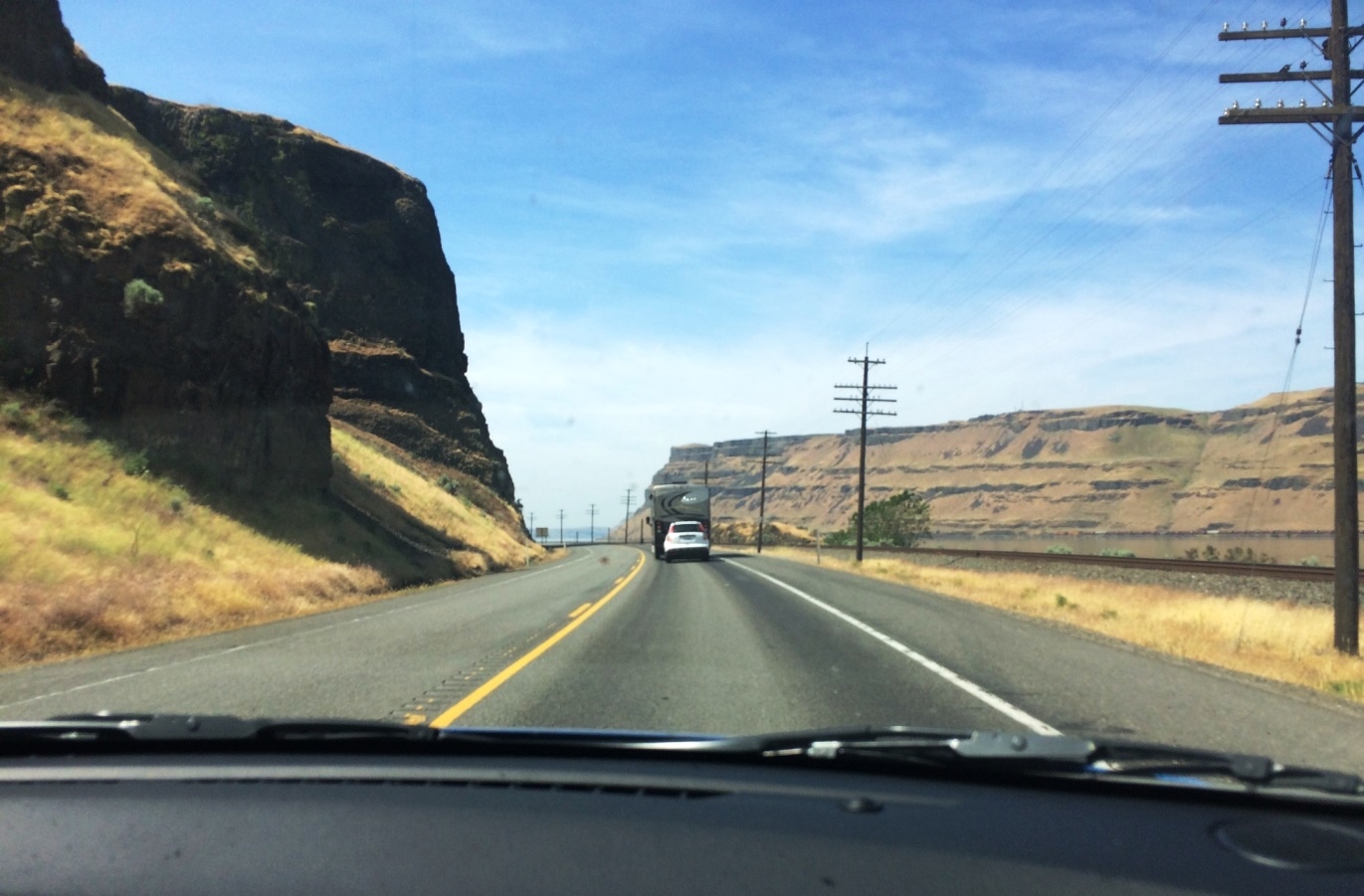
After a good night sleep and a nice breakfast, we headed out at 9:30 toward the Columbia River and the gorge (Definition:a narrow cleft with steep, rocky walls, especially one through which a stream or river runs) between Washington and Oregon states. The Oregon side of the gorge is on the left and the Washington side on the right.


We saw many many wind turbines along the way. Because of the heavy late spring rains, some green was still visible.

We first traveled on the Oregon side of the river where the highway was much wider than the Washington side. The road took a lot of hard work to make, carving through basalt and other rocks.
Nava was very impressed by this different landscape and the gorge itself.
After several hours of driving, we stopped at Hat Rock State Park to stretch our legs and walk a bit.
This site was named by the Lewis and Clark expedition when the stopped there in October, 1805. Rising some 70 feet above its base, the monolith was the first land form in Oregon named in the journals of Lewis and Clark. Clark made this note:
“... S.W. 14 miles a rock in a Lar.d (larboard or left side of the boat) resembling a hat just below a rapid at the lower Point of an Island in the Midl: [sic] of the river ...”


Geologists say Hat Rock, and another outcropping in the park known as Boat Rock, are remnants of a 12-million year old basalt flow. Catastrophic Ice Age floods eventually left both outcroppings and others exposed as they scoured the Columbia River Gorge. Hot Rock and other hard deposits of columnar basalt in this are withstood 50 to 100 collosal floods which flowed from breaking ice dams in western Montana.

 Lot of dry grasses surrounded us.

There was a lovely (well irrigated) park with lawn and picnic areas along the Columbia River at the park.
 We drove around and saw the rock from a different angle.


There were also wind turbines on the Washington side of the gorge as the gorge is a very windy area.

Samuel Hill, patron of this region,

established a town site here called Maryhill, named for his wife and daughter, with a post office, hotel general store, and nearly ten miles of experimental paved roads. He had hope to establish an "ideal" agricultural community here. His experiment did not succeed, and the large home that he had built for his family eventually became the Maryhill Museum. It had an amazing view of the river below. And it is HUGE! It is much better as a museum than as a private residence! Hill earned his money building the railroad in the west and the first paved highways out west.

Hill, a Quaker passivist, also constructed this Stonehenge replica, after having visited the original one in England in the second decade of the 1900s. Although his design was not a perfect replica of the original Stonehenge built 4-5,000 years ago, it was close. The structure below, a memorial to 13 young men from Klikitat County, is the first monument in the US for military personnel who died in the first World War. It had turned cloudy and the next day rain was predicted.


The Museum is open from 10 to 5 p.m. daily from March 15 to November 15. It is run by a trust that Hill set up. Admission is $9, $8 for seniors.The museum has an amazing eclectic collection.
In addition to special exhibits, on permanent view are more than 80 works by Auguste Rodin, European and American paintings, objects from the palaces of the Queen of Romania, Orthodox icons, unique chess sets, and the Théâtre de la Mode, featuring small-scale mannequins attired in designer fashions of post-World War II France. Baskets of the indigenous people of North America were a collecting interest of Sam Hill; today the museum’s American Indian collection represents nearly every tradition and style in North America, with works of art from prehistoric through contemporary. The museum’s William and Catherine Dickson Sculpture Park features more than a dozen large-scale works by Northwest artists.
When Hill was in Europe in the second decade of the 1900s, he met the Queen of Romania and they had a friendship that lasted until her death. The display of furniture and clothing on the entry level includes gifts from the Queen.

Queen Marie designed the cabinet below. In the early years of her married life, when she was often lonely and bored, she had a number of creative pastimes including designing and sculpting furniture. One of her favorite symbols was the lily, then popular as an Art Nouveau symbol. She often used it in her furniture.

There was some modern art in the building including the following:


And then there was this well known piece:
Auguste Rodin was born in 1840 to a working class family in Paris. A large room at Maryhill is dedicated to Rodin's work. Rodin and Loie Fuller had a strong friendship. Fuller, an innovative American dancer, performed in Paris at the turn of the century, and the two met. Rodin used dance movement to inspire his work. Loie was highly influential in introducing Rodin and his sculpture to America. Loie met Sam Hill at the International Exhibition in San Francisco in 2015. They became friends, and she suggested to Sam that he turn the unfinished and abandoned mansion at Maryhill into an Art Museum. In 1921 he purchased from her a number of Rodin's drawings in addition to several plaster models and bronze castings. He purchased all but three of his Rodin sculptures on exhibit at Maryhill from her
.

 I had not known anything about The Gates of Hell, so this explanation helped me.

 There were also a number of fragments of sculptures, which were fascinating, especially the hands and feet.
Below are some of the Indian baskets and other items he collected.


 We then went down to the lowest level to the small cafe and found an amazing collection of chess sets. One of the directors of the museum loved chess sets and set about to collect them.


The following book in the small gift shop tells a lot about Sam Hill's colorful life!

We spontaneously stopped at the Temani Pesh-wa petroglyph trail. No one else was there. The rocks had been moved to this place when dams flooded their original site.


It was getting late, so we headed west, crossing the river to the Oregon side for faster travel. We went off the highway to enjoy the lush greenery, a huge change from what we had seen just an hour before, and stopped at Horsetail Falls and Multnomah Falls.

In some ways, Horsetail was as beautiful as Multnomah but very few people were at the former and the latter was crowded--in part because of its tourist services. We had been to the falls are in 2015 but I will never tire to return to see these powerful works of nature.
We tried very hard to find Bridal Falls, but although our GPS had said that we had arrived, we never did find it.
We drove toward home, taking a brief detour to find the Mt. St. Helen's turn off and the museum 5 miles off the road.
We picked up Ziva at 10 p.m. and were home twenty minutes later. Our last day was long and included a lot of driving, but Nava got to see the amazing gorge and both of us saw the Maryhill area for the first time.
We accomplished a lot in three days and had a lot of fun too! It was great to have such a wonderful travel companion!

Below: driving on the Oregon side with Washington cliffs on the right

We first traveled on the Oregon side of the river where the highway was much wider than the Washington side. The road took a lot of hard work to make, carving through basalt and other rocks.
Nava was very impressed by this different landscape and the gorge itself.
After several hours of driving, we stopped at Hat Rock State Park to stretch our legs and walk a bit.
This site was named by the Lewis and Clark expedition when the stopped there in October, 1805. Rising some 70 feet above its base, the monolith was the first land form in Oregon named in the journals of Lewis and Clark. Clark made this note:
“... S.W. 14 miles a rock in a Lar.d (larboard or left side of the boat) resembling a hat just below a rapid at the lower Point of an Island in the Midl: [sic] of the river ...”


Geologists say Hat Rock, and another outcropping in the park known as Boat Rock, are remnants of a 12-million year old basalt flow. Catastrophic Ice Age floods eventually left both outcroppings and others exposed as they scoured the Columbia River Gorge. Hot Rock and other hard deposits of columnar basalt in this are withstood 50 to 100 collosal floods which flowed from breaking ice dams in western Montana.


There was a lovely (well irrigated) park with lawn and picnic areas along the Columbia River at the park.


 |
| Canada Geese along the river inlet bank |
We drove on for a half hour and stopped on the side of the road for our picnic lunch. Yes, it was windy here too!
 |
| Road Trip 2017 |
Then we drove over the bridge and across the river to Maryhill, Washington.


Samuel Hill, patron of this region,


Hill, a Quaker passivist, also constructed this Stonehenge replica, after having visited the original one in England in the second decade of the 1900s. Although his design was not a perfect replica of the original Stonehenge built 4-5,000 years ago, it was close. The structure below, a memorial to 13 young men from Klikitat County, is the first monument in the US for military personnel who died in the first World War. It had turned cloudy and the next day rain was predicted.


Below is a view of the river and the bridge we crossed, taken a bit below Stonehenge on our way to the Maryhill Museum.


The Museum is open from 10 to 5 p.m. daily from March 15 to November 15. It is run by a trust that Hill set up. Admission is $9, $8 for seniors.The museum has an amazing eclectic collection.
In addition to special exhibits, on permanent view are more than 80 works by Auguste Rodin, European and American paintings, objects from the palaces of the Queen of Romania, Orthodox icons, unique chess sets, and the Théâtre de la Mode, featuring small-scale mannequins attired in designer fashions of post-World War II France. Baskets of the indigenous people of North America were a collecting interest of Sam Hill; today the museum’s American Indian collection represents nearly every tradition and style in North America, with works of art from prehistoric through contemporary. The museum’s William and Catherine Dickson Sculpture Park features more than a dozen large-scale works by Northwest artists.
When Hill was in Europe in the second decade of the 1900s, he met the Queen of Romania and they had a friendship that lasted until her death. The display of furniture and clothing on the entry level includes gifts from the Queen.

 |
| Romanian royal furniture |

There was some modern art in the building including the following:


And then there was this well known piece:
 |
| Monarch of the Herd, c 1915 by Fred Achertr |
 |
| Plaster of Eve for the Gates of Hell |
 |
| The Age of Bronze,the first life size sculpture exhibited by Rodin, 1877 This cast is a reduction in the original size |
 |
| Falling Caryatid, bearing her stone, 1881, originally in the upper left corner of Gates of Hell |


 |
| The Thinker, 1880 |
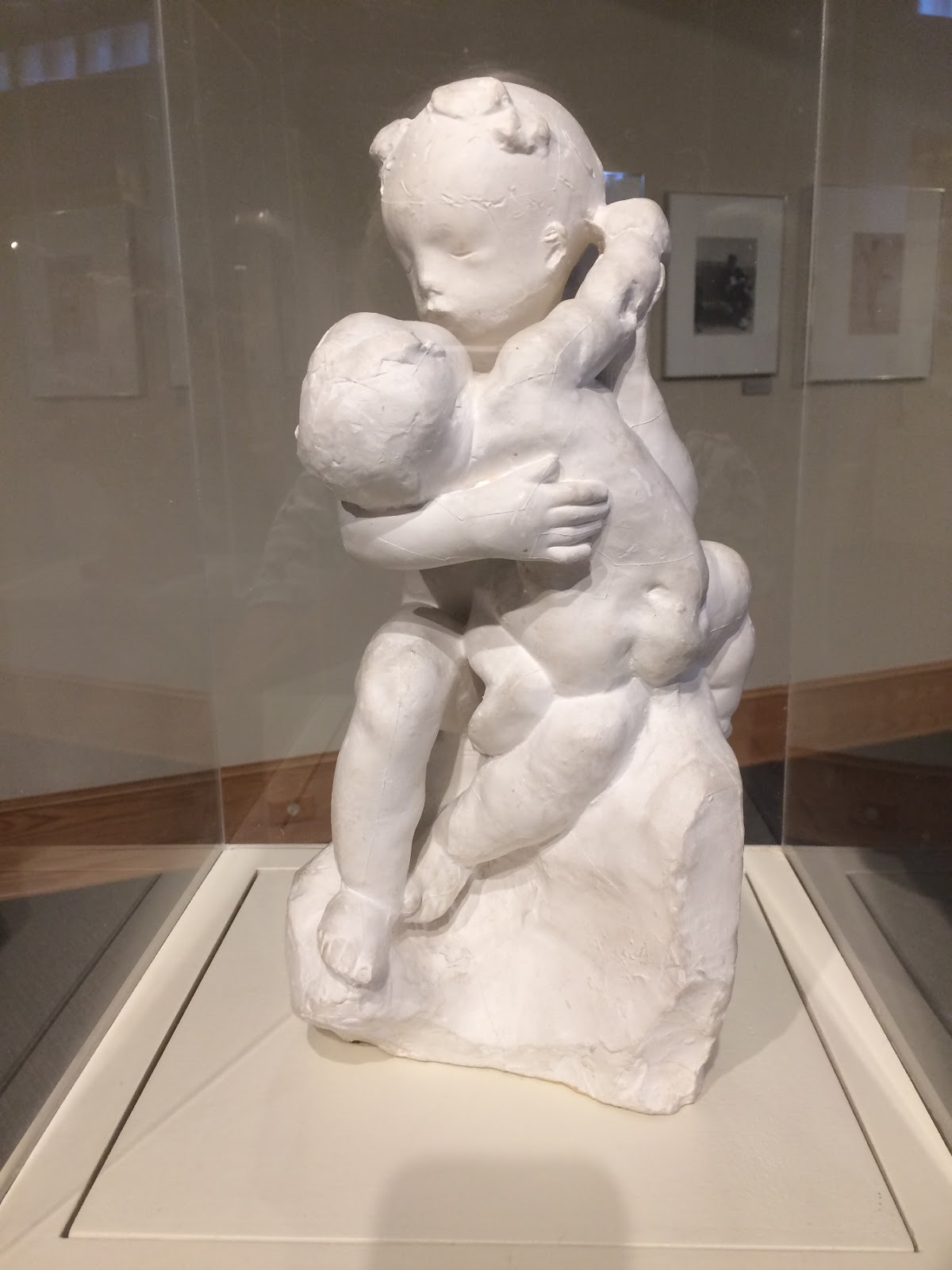 |
| Embracing Children |

Below are some of the Indian baskets and other items he collected.


 |
| And More |
 |
| A tiny section of items stored |

We spontaneously stopped at the Temani Pesh-wa petroglyph trail. No one else was there. The rocks had been moved to this place when dams flooded their original site.


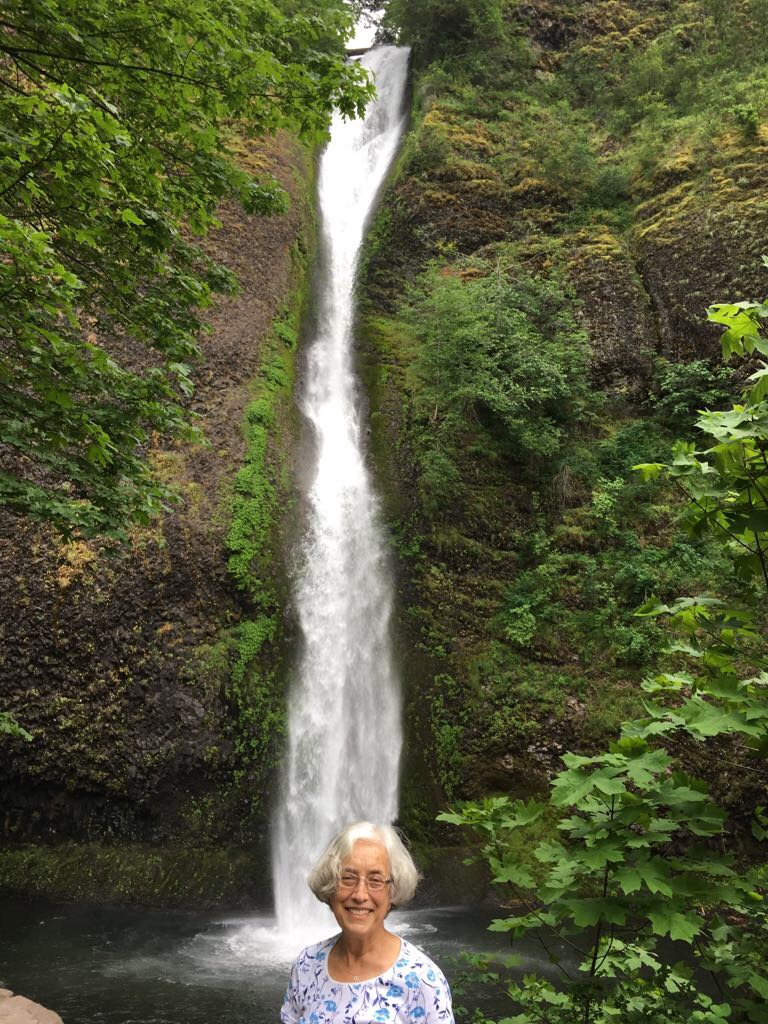 |
| Horsetail Falls |

 |
| Multnomah Falls |
We tried very hard to find Bridal Falls, but although our GPS had said that we had arrived, we never did find it.
We drove toward home, taking a brief detour to find the Mt. St. Helen's turn off and the museum 5 miles off the road.
We picked up Ziva at 10 p.m. and were home twenty minutes later. Our last day was long and included a lot of driving, but Nava got to see the amazing gorge and both of us saw the Maryhill area for the first time.
We accomplished a lot in three days and had a lot of fun too! It was great to have such a wonderful travel companion!
